
The Native Village of Napakiak has created a Managed Retreat Plan to relocate it’s 344 residents away from riverine erosion.
Located along the north bank of the Kuskokwim River in Alaska, the community has been losing land for decades — sometimes having to use trailers and other heavy equipment to pull erosion-threatened buildings and structures away from the river to safer locations.
However, as several hazardous factors combine — mostly abetted by climate change — their efforts have reached a breaking point and time has run out.
With the river now threatening critical infrastructure, including their airstrip, school, fuel tank farm, and the only community water source, the town has decided to retreat.
What Is A Managed Retreat Plan
By definition, a managed retreat plan is the, “coordinated process of voluntarily and equitably relocating people, structures, and infrastructure away from vulnerable coastal areas in response to episodic or chronic threats in order to facilitate the transition of individual people, communities, and ecosystems (both species and habitats) inland.”
For Nepakiak, the plan is more than just a means to relocate, it’s a permanent solution.
Why The Native Village of Nepakiak Needs A Managed Retreat Plan
As a traditional Yup’ik community, the village has an emphasis on subsistence lifestyle due to both its heritage and unique remoteness.

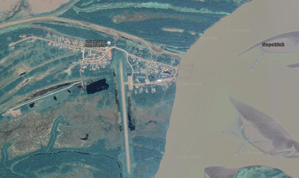
The town is situated on a tiny island surrounded by the Johnson Slough on the northern and western sides, and the Kuskokwim River on the eastern and southern sides. As the plan describes, “it is located on the right bank of the Kuskokwim River, approximately 12 miles downriver from Bethel and eight miles by air.”
It also sits within the second largest National Wildlife Refuge in the country — the Yukon Delta National Wildlife Refuge — which supports one of the most diverse populations of water birds in the world and has an estimated 2 million salmon that swim directly in front of Napakiak on an annual basis.
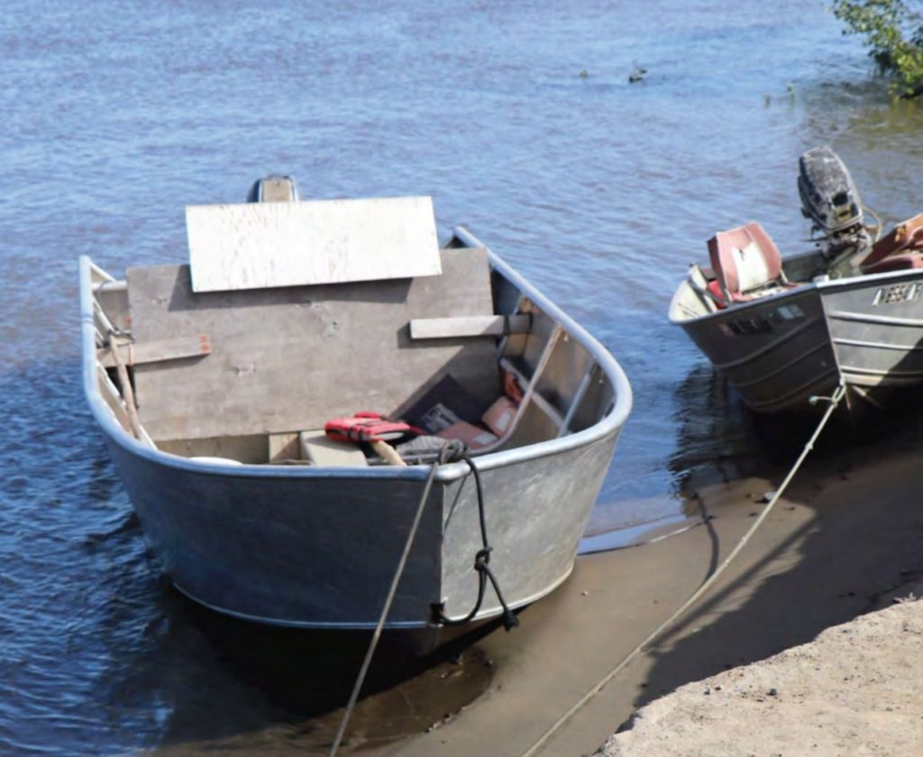
While the town is typically only accessible by air or boat, there is also a “single marked trail” which allows travel by snowmobiles in the winter and all-terrain vehicles in the summer. Additionally, there’s a summertime barge service (which provides heavy equipment and bulk fuel deliveries) and a hovercraft service from Bethel, which brings in goods.
“What Is The Problem” and “Why This Is A Perfect Example Of A Managed Retreat Case Study”
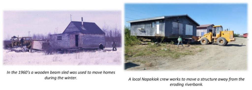
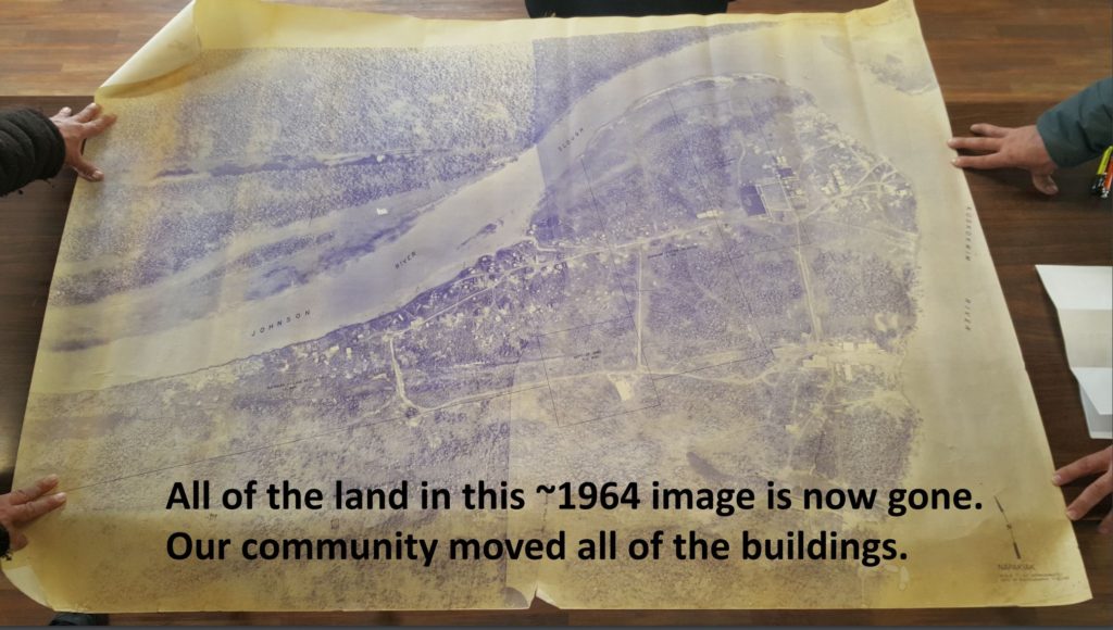
Residents have been coping with erosion since the 1960s; however, while the town typically pulls farther back and relocates its buildings, its larger infrastructure has proved challenging to move.
“Residents have effectively used their limited heavy equipment to gradually move homes and structures as they are threatened. In the early years, a wooden beam sled was constructed and used to drag homes with a tractor. A custom trailer was purchased more recently and used with the City’s dozer and local manpower to continue their efforts including buildings such as the City garage and fire station (moved in 2019). Most of the homes in the original settled area have been moved in this manner since the 1960s. Larger, community infrastructure is more challenging. The original school was lost to the river in a matter of days during a fall storm. The community is using their third runway, their second water source well, and has moved the cemetery once already” – Napakiak Managed Retreat Plan
Several studies have highlighted just how dire the situation has become.
According to the U.S. Army Corps of Engineers’ (USACE) Alaska Baseline Erosion Assessment (BEA) conducted in 2009, Napakiak was designated a “Priority Action Community” because “erosion issues in these communities warrant immediate and substantial Federal, State, or other intervention.”
The most recent study – the Environmental Risk Assessment to Increase Napakiak Community and Infrastructure Resilience – found that, “the majority of the current critical community infrastructure in Napakiak is expected to be eliminated by 2030.”
Why Is It Finally Time To Retreat?
As previously stated, Napakika is no strager to relocation, having continually experienced “erosion incidents” throughout its history; the issue today however, is that erosion has exponentially increased in both impact and frequency.
While erosion at the river bank is typical during ice-free months, there has been a steady progression of greater acceleration when the water is high — especially when a storm event brings in wave action. The situation has become critical as the rate of acceleration has far outpaced the community’s ability to respond.
They are losing 45 feet per year
According Rural Utility Business Advisor (RUBA) personnel with the State of Alaska, the city has experienced a loss of 164 feet in just under four years.
During their visit in 2019, they found that the shoreline measured 201 feet from the water plant, a critical piece of infrastructure for the community. For comparison, the shoreline was measured at 242 feet in June 2019, 299 feet in January of 2018, 332 feet in November of 2016, and 365 feet in April of 2016.
That makes the rate of erosion at 45 feet per year. At the time of the plan’s publication (summer 2020), the water plant, community well, and watering point were all approximately 140 feet away from the river.
Managed Retreat Advantages and Managed Retreat Disadvantages
According to the executive summary within the plan, “The mission of the Napakiak Managed Retreat Plan is to document the efforts of the community to protect their resources, the coordination between community members and agencies, define the extent of the threat, and to provide the framework for an orderly retreat of the community to a safe and sustainable location.”
In developing that framework, 4 possible plans were considered:
- Short Term Plan — Retreat from Imminently Threatened Areas.
- Long Term Plan 1 — Moving to the Bluff– Phased/Flexible Retreat
- Long Term Plan 2 — Moving to the Bluff– Phased/Direct Retreat
- Long Term Plan 3 — Remain on the Island
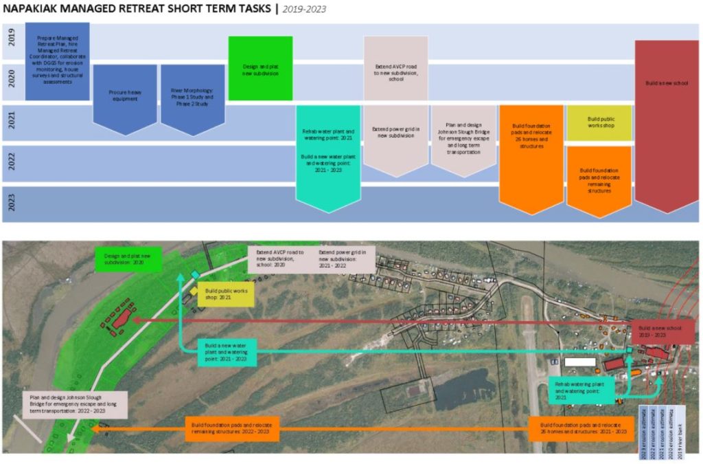
Short Term Plan — Retreat From Imminently Threatened Areas
In this situation, Napakiak hopes to retreat/pull back imminently threatened structures from the lower side of the island (western side) while slowly planning and preparing for a long-term retreat to the higher area (eastern bluff site).
Long Term Plan 1 — Moving to the Bluff– Phased/Flexible Retreat
This appears to be a “wait and see” approach. They will watch and react as necessary while implementing the short term plan. If the data and predictions are correct, they will begin retreating; if they are not correct, they will adapt as necessary.
Advantages (as identified in the plan):
- Residents will be able to watch and observe and make adjustments as necessary before committing to a full retreat plan to the bluff.
- Having more time will allow for future studies on erosion and flooding.
- The plan to build a new school will still proceed on as planned.
Disadvantages (as identified in the plan)
- The community will have to to develop a firm and final path forward which would impact some funding sources that would prefer to see a final decision made.
- Comparatively, overall managed retreat costs will be higher due to the longer duration of duplicating structures, buildings, and facilities.
Long Term Plan 2 — Moving to the Bluff– Phased/Direct Retreat
This plan factors in what is already known (predictions, data, past experiences) and calls for a direct, phased retreat from the island.
Advantages (as identified in the plan):
- A firm and clear path forward which will be appealing to agencies that are willing to fund the relocation.
- The managed retreat costs will be lower than a flexible approach due to the duration being less and infrastructure not having to be duplicated.
Disadvantages (as identified in the plan):
- There is no time for observation; residents have to commit immediately. Should the river change course and not do as predicted, the investment will have been for nothing.
- School district costs will be higher due to temporary school infrastructure being required for several years.
- A very large portion of funding will be required sooner than if a flexible retreat were pursued. This could prove challenging for agencies trying to fund the process.
Long Term Plan 3 — Remain on the Island
This is only possible if the river changes course or if erosion starts to decrease significantly; however, the short term plan will still remain in effect.
Advantages / Disadvantages (as identified in the plan):
The only advantages and disadvantages listed for long term plan 3 include, “Remaining on the island is the preferred alternative for residents should the river allow it. This alternative is not directly comparable to the Phased/Flexible or Phased/Direct alternatives.”
For Napakiak, The Managed Retreat Plan Is A Means Of Survival
If the city and tribe are unable to relocate, their land and community will undoubtedly disappear. The bottom line? Napakiak isn’t just fighting to keep it’s infrastructure, it’s fighting for survival. If they do nothing, their way of life will cease to exist.
The Center for Environmentally Threatened Communities — a partnership between the Denali Commission, the Alaska Native Tribal Health Consortium (ANTHC), and the Climate Justice Resilience Fund (CJRF) — found that despite the challenges, the plan is being well received.
Publishing a monthly newsletter about threatened communities in Alaska, they interviewed three people involved in the Napakiak Managed Retreat and Land Use Plan and found that there’s at least some optimism for the future.
Walter Nelson — the Managed Retreat Coordinator with the Native Village of Napakiak — described the process and plan as critical for the community.
“It’s our roadmap. It’s our future. We need to keep using it to keep moving forward. Without this plan, Napakiak would not be where it is at now.”
When asked how this process was different from past efforts, he said, “We do what we have to do here in Napakiak. We have been moving buildings mainly on our own, and, when funding wasn’t available, we had to do what we had to do. But we now face bigger issues. Today, the school is only 97 feet from the eroding river and our only water source is only 134 feet from erosion. After the two big community planning meetings, we realized that all community organizations needed to work together.”
He also discussed how the community developed the plan.
“We met so many times about this plan. Each one of the entities here in Napakiak was involved along with community members to give feedback and approve the plan in September of last year. The plan is a living document for our community, for both the short and long-range. We use it quite often. When there is a question we look back at it and say, “oh no this is the way we want it” and we work it out. If for some reason we don’t agree on it, we get together and iron out the issues.”
Heather Gross, who works with Summit Consulting Services as a civil engineer (and has been heavily involved since February 2019), said the process did have its ups and downs.
“My favorite part was getting to know everyone in Napakiak and seeing how well everyone in the community works together and supports each other. It has been a pleasure working in that environment and getting to know everyone personally. The most difficult part was looking at all the big tasks that are coming in the future and then trying to find a way to accomplish those tasks with all these funding barriers that have their own requirements and limitations.”
Moving Forward
As the plan indicates, Napakiak residents are moving forward and implementing all the necessary short-term goals necessary to address immediate threats. Even though they expect the river to continue to behave in the same manner as it always has, they agree that short term mitigation is the simplest and most effective means to address the problem. However, while the short term plan is underway, they hope to answer some key questions, pick a strategy, and eventually implement some long term actions.
If you would like to read the plan in its entirety, you can find it here.