According to a new report by Climate Central — an independent research group that conducts scientific research on climate change — New Orleans, Newark, and New York City have a pretty significant heat problem.
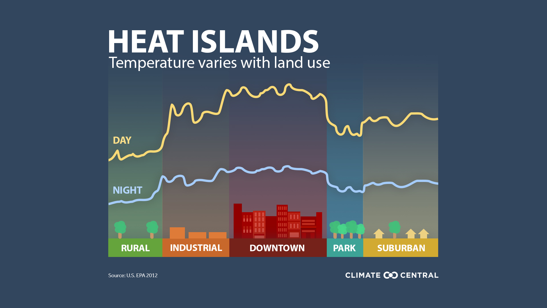
These cities, along with places such as San Francisco and Houston, have something called “urban heat islands” — metropolitan areas that are hotter than their outlying regions — where heat can sometimes be 15°F to 20°F hotter than their neighboring rural and suburban communities.
This is because humans, as environmental manipulators, have built cities over time, not thinking about long-term consequences. And now, as global warming begins to rear its ugly head, conditions are set to deteriorate even further.
According to the report, downtown areas are at greatest risk where temperatures have risen due to: (1) human created heat emissions, (2) less vegetative cover, (3) less airflow and wind (mostly caused by buildings), and (4) a whole lot of heat-trapping pavement.
- “There are more human-created heat emissions. Population density matters. Heat emissions come from all the activities of city life: transportation, machinery and appliances, industrial facilities, and the heating and cooling of buildings. During a heat wave, air conditioning from urban buildings can add 20% more heat to the outside air, compared to regular summer weather.”
- “Less vegetation means reduced evaporative cooling. Partially through a process called evapotranspiration, plants help cool the air. Leaves absorb some of the heat energy from the air, causing evaporation of water within the leaves. Because evaporation is a cooling process, the surrounding air slightly cools. Replacing trees with buildings or concrete reduces this natural cooling effect. The flip side is that trees and vegetation, alone or in combination with shading, can help reduce peak summer temperatures by 2–9°F (1–5°C) in an urban area.”
- “The shape and height of buildings can impact airflow. Scientists call it “increased surface roughness.” Simply, the size and dimensions of buildings influence how air moves through a city during the day, playing a large role in the trapping or dissipation of heat.”
- “Narrow urban canyons cause warmer air to linger over cities, especially at night. Tall buildings provide multiple surfaces that reflect and absorb sunlight and also block wind. This can create large masses of trapped hot air that cannot release heat very readily because of the obstruction of neighboring buildings. Besides preventing cooling down, this type of urban geometry can prevent pollutants from dissipating, reducing air quality.”
- “Miles of hard, dark surfaces in a city absorb and then radiate back heat. Albedo indicates the percentage of sunlight reflected by a surface. Lower albedo means that a surface is absorbing more sunlight and thus heating up. Cities’ roads and sidewalks, buildings and parking lots—whether brick, asphalt, or concrete—all have low albedo.”
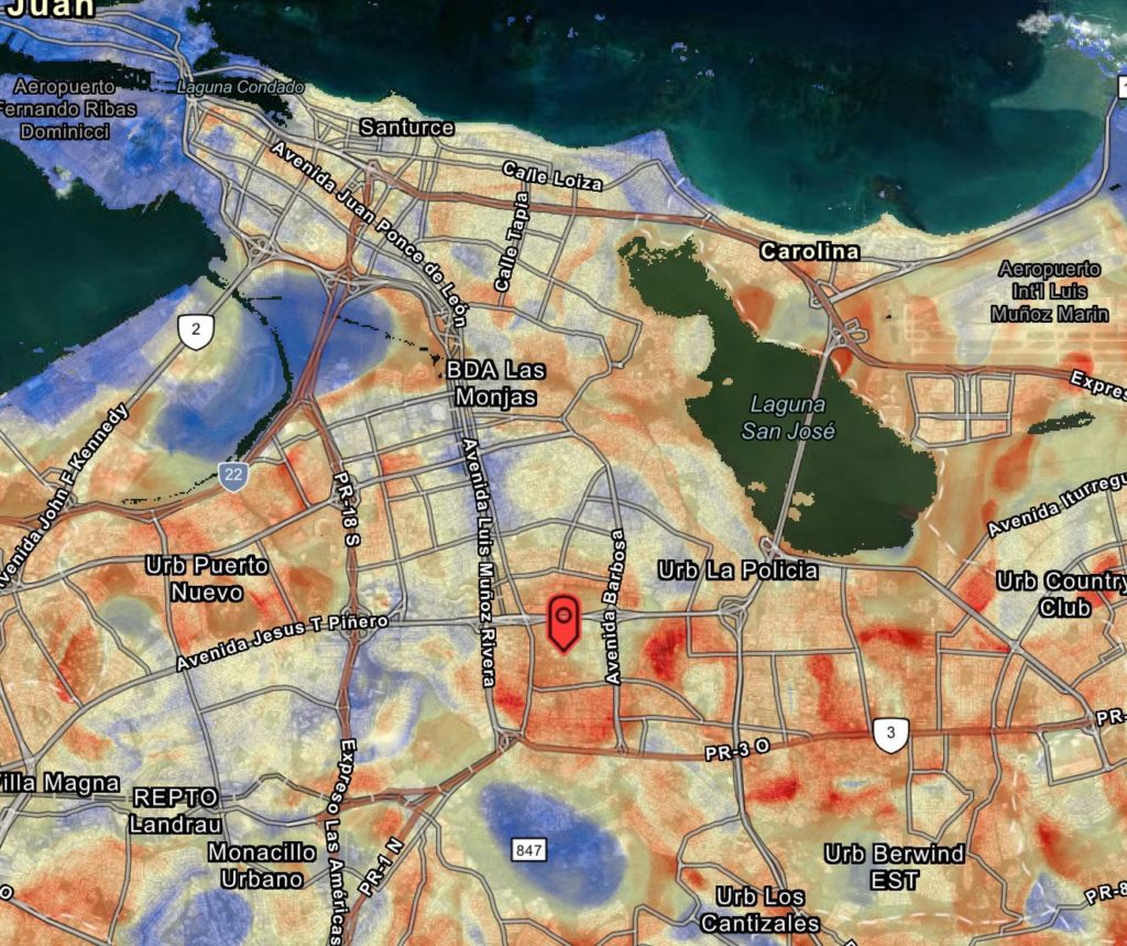
Example: Urban Heat in San Juan, Puerto Rico
“Climate Central created an index to evaluate the intensity of urban heat islands (UHI) and applied it to 159 cities in the U.S. . . . By measuring the type of land cover in each city, from greenspace to paved areas, and factoring in building height and population density, our research team adapted the Sangiorgio model to estimate how urban heat island intensity varies across U.S. cities.”
Image Credit: UHI Map Viewer
As the report indicates, the people most in danger of urban heat are those low-income communities and communities of color that have already been marginalized to some of the most environmentally hazardous parts of the city. And as research has shown, these communities have not only been subjected to discriminatory practices such as redlining, but they are least equipped to handle rising temperatures.
What’s the solution? Well, according to the report, it appears to be a combination of personal and community-wide initiatives that get to the source of urban heat, and none of them should come as a surprise. The recommended initiatives include planting trees, building green roofs, whitewashing roads and sidewalks, and a general movement towards solar energy.
To read the full report, see the link below. Also, feel free to explore other environmental and social justice tools listed on Millennial Cities.
The top 20 cities for heat intensity are:
- New Orleans
- Newark, New Jersey
- New York City
- Houston
- San Francisco
- Boston
- Chicago
- Miami
- Baltimore, Maryland
- Providence, Rhode Island
- Sacramento
- Salinas, California
- Burlington, Vermont
- Bend, Oregon
- Cleveland, Ohio
- Detroit
- Erie, Pennsylvania
- Fresno, California
- Lafayette, Louisiana
- McAllen, Texas
Full Report: Hot Zones, Urban Heat Islands, a research brief by Climate Central; originally published on July 14, 2021.